


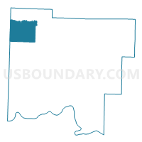
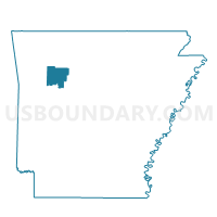
Dickerson Voting District, Johnson County, Arkansas
About
Outline

Summary
| Unique Area Identifier | 526994 |
| Name | Dickerson Voting District |
| County | Johnson County |
| State | Arkansas |
| Area (square miles) | 30.17 |
| Land Area (square miles) | 30.04 |
| Water Area (square miles) | 0.13 |
| % of Land Area | 99.57 |
| % of Water Area | 0.43 |
| Latitude of the Internal Point | 35.68575540 |
| Longtitude of the Internal Point | -93.63262270 |
Maps

Graphs
Select a template below for downloading or customizing gragh for Dickerson Voting District, Johnson County, Arkansas


Neighbors
Neighoring Voting District (by Name) Neighboring Voting District on the Map
- Voting District 3-B, Franklin County, AR
- Batson Voting District, Johnson County, AR
- Hill Voting District, Johnson County, AR
- J P Dist 3-C, Franklin County, AR
- Low Gap Voting District, Johnson County, AR
- Mulberry Voting District, Johnson County, AR
Top 10 Neighboring County Subdivision (by Population) Neighboring County Subdivision on the Map
- Mountain township, Franklin County, AR (307)
- Batson township, Johnson County, AR (219)
- Mulberry township, Johnson County, AR (170)
- Low Gap township, Johnson County, AR (136)
- Dickerson-Hill township, Johnson County, AR (104)
- Limestone township, Franklin County, AR (18)
- Cobb township, Franklin County, AR (0)